Skip to content

A Municipal Inventory product

Visor Urbanismo Your municipality's urban planning information, in one click

Click on any point of the municipal area and get its urban planning sheet: land classification, applicable zoning ordinance and rural land conditions. With a PDF report to print or share.

  • Adapted to the LISTA
  • Official data
  • Any device
  • No installation
Benahadux viewer showing land classification: urban land with its zoning ordinances, development units and land zoned for development.
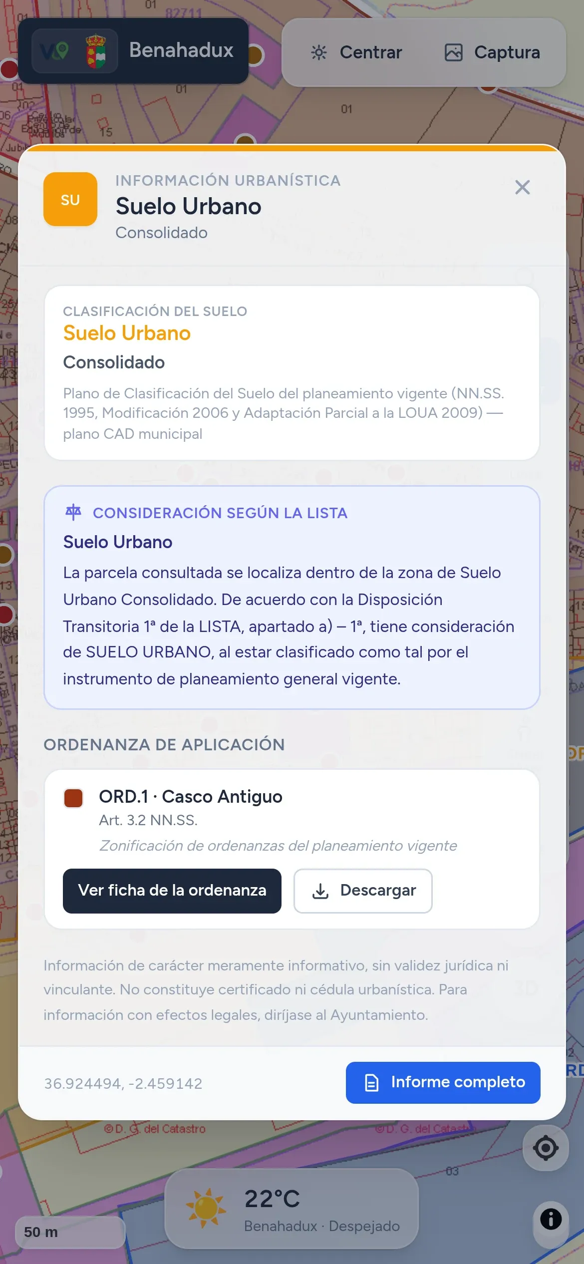
Urban planning sheet of the viewer on a mobile phone.

As simple as that

From an urban planning question to a report, in three steps

No appointment, no searching through PDF maps and no interpreting regulations: the viewer gathers all the information about a point and explains it in plain language.

  1. Click or search

    Tap any point on the map or type a cadastral reference or an address.

  2. Check the sheet

    Land classification, planning area, zoning ordinance and rural land conditions, on a single sheet.

  3. Download the report

    Print it, save it as a PDF or share it with a link.

Who it is for

A viewer designed for the whole municipality

  • For the Town Council

    It publishes its urban plan in a clear way, accessible to everyone, with its coat of arms and on its own subdomain.

  • For the municipal technician

    All the urban planning information about a point on a single sheet, with the report ready to hand over.

  • For residents and professionals

    They look up their plot whenever they want, from home or from their phone, without registering or making an appointment.

Features

Everything Visor Urbanismo does

Real screenshots of the Benahadux viewer, in service.

Urban planning sheet in one click

Click on any point of the municipal area and the viewer answers instantly: land classification, planning area and the zoning ordinance that applies, in the same order a municipal technician checks them.

  • Land classification and category
  • Planning area and its sheet
  • Applicable zoning ordinance with its parameters
  • Rural land conditions affecting the point
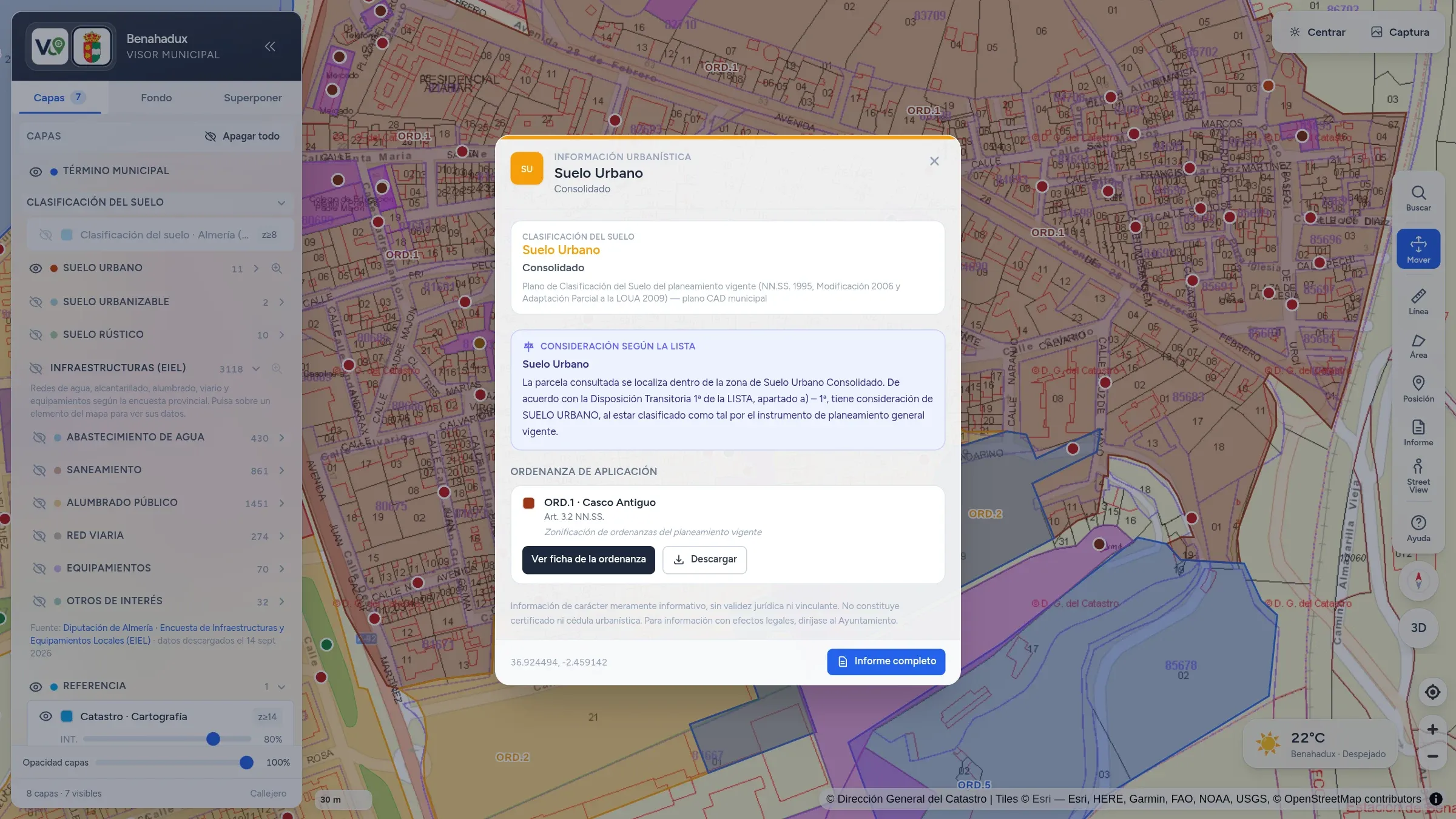
Urban planning sheet of a point in the old town of Benahadux: consolidated urban land, status under the LISTA and zoning ordinance ORD.1 Casco Antiguo.
Real screenshot

Urban planning report in PDF

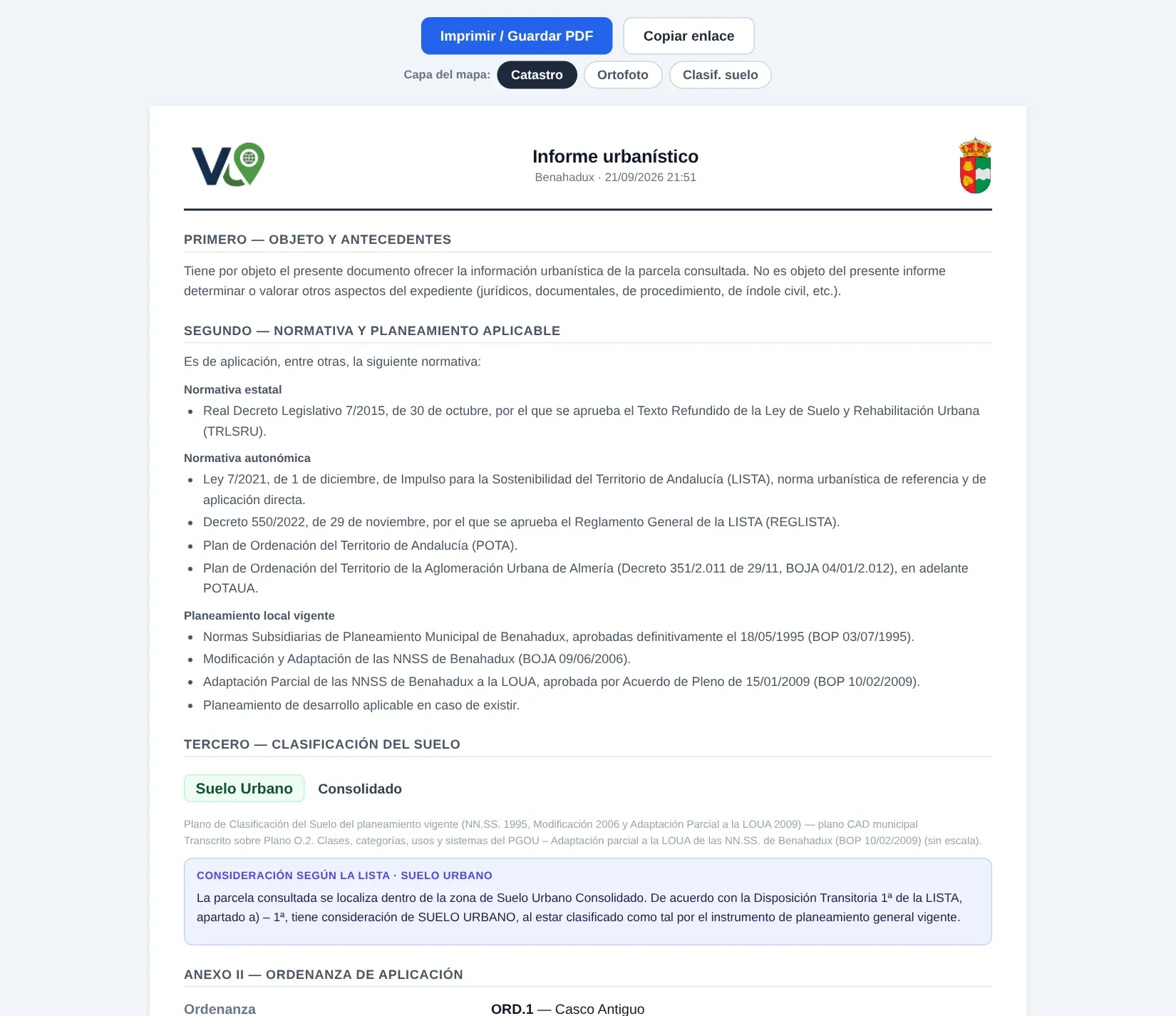
With one button, the sheet becomes a report ready to print, save as a PDF or send by link, with the applicable regulations and the Town Council's coat of arms and details.

  • Applicable national, regional and municipal regulations
  • Zoning ordinance parameters: buildability, number of floors, minimum plot size…
  • Print, save as PDF or share by link
  • With the Town Council's coat of arms and details
Urban planning report of Benahadux: purpose, applicable regulations, land classification and an annex with the zoning ordinance parameters.
Real screenshot

Adapted to the LISTA

When the current urban plan predates the LISTA (Andalusia's land-use law, Law 7/2021), the viewer explains how each class of land is treated today under its First Transitional Provision, on the sheet and in the report.

  • Status under the First Transitional Provision for each class of land
  • Specific notices in areas under a transitional regime
  • On the on-screen sheet and in the report
  • Current urban plan cited with dates and official gazettes
The viewer on a mobile phone: urban planning sheet with the «Status under the LISTA» box.
Real screenshot

Search by cadastral reference

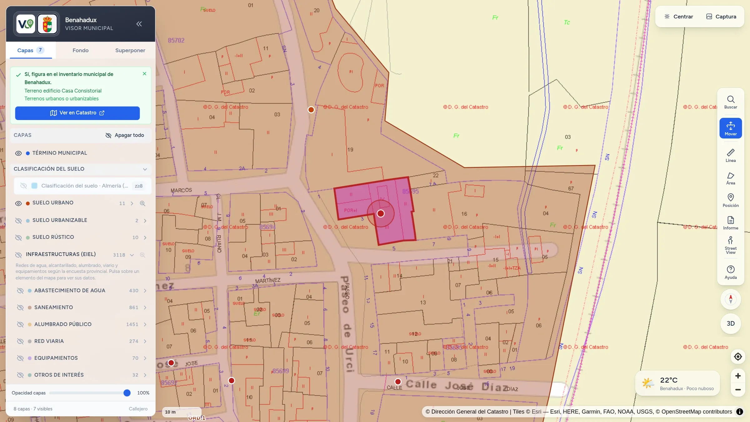
Type a cadastral reference (the parcel ID in the Spanish land registry) and the viewer draws the plot on the map. If it is a municipal asset, it tells you so and links to its record in the inventory.

  • Plot outline on the Spanish Cadastre mapping
  • Land classification of the plot
  • Notice if it is listed in the municipal inventory
  • Search also by address or by inventory record
Search for the cadastral reference of the Benahadux Town Hall: highlighted plot and notice that it is listed in the municipal inventory.
Real screenshot

The municipality's urban plan and zoning ordinances

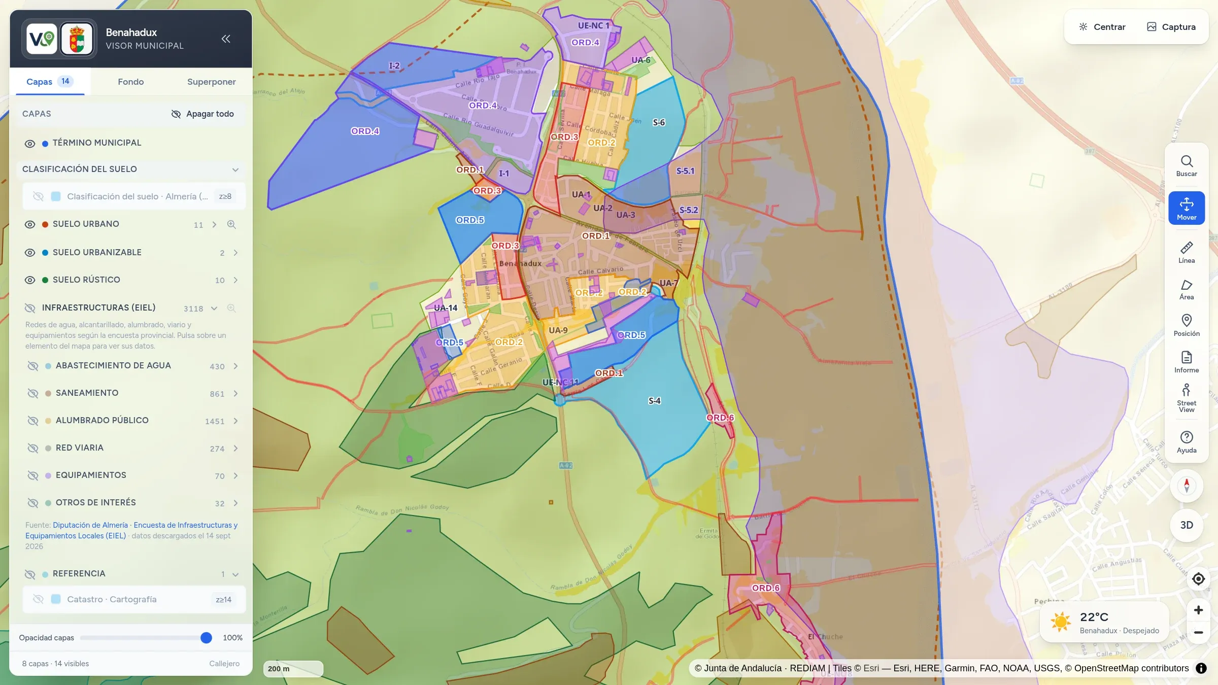
Urban, developable and rural land, with their management areas and zoning ordinances, drawn on the map from the Town Council's maps and reviewed with its technician.

  • Sheets for development units and sectors
  • Zoning ordinances with download of the original document
  • Approved detailed plans, downloadable
  • The Town Council's own layers from its DXF maps
Land classification of Benahadux: urban land with its zoning ordinances, development units and sectors of developable land labeled on the map.
Real screenshot

Rural land, risks and protection

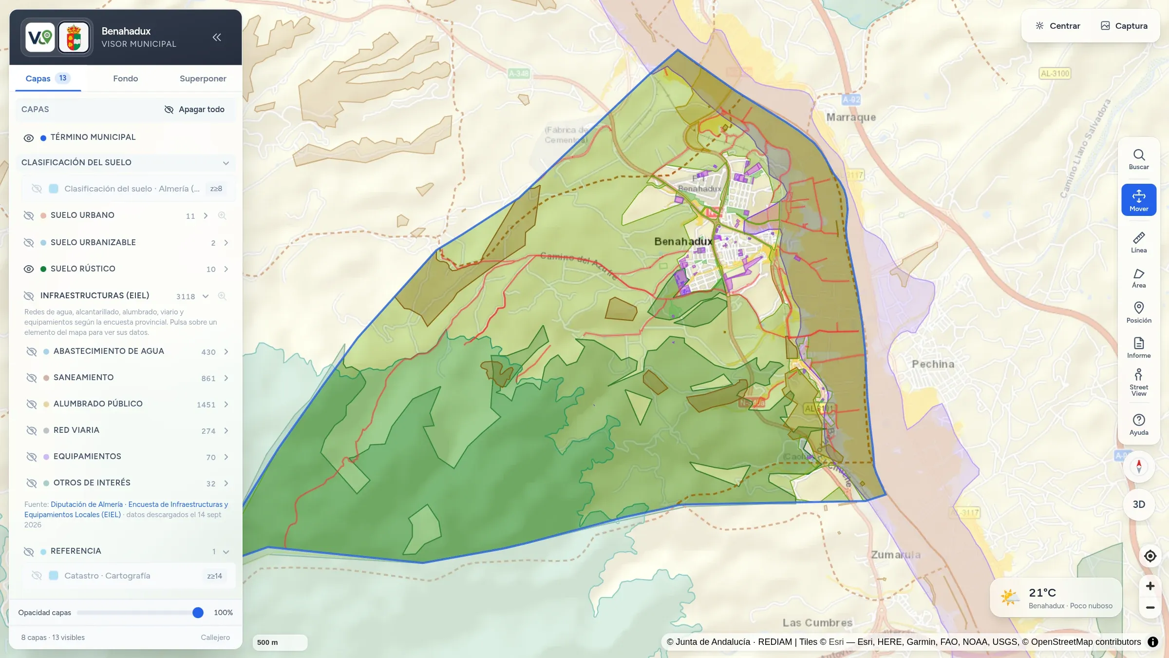
Flood zones, protected areas, livestock trails or historic heritage: the viewer warns you of everything that affects a point, even if that layer is turned off on the map.

  • Flood zones for 100-year and 500-year return periods
  • Natura 2000 network, livestock trails and protected areas
  • Public forests, special plans and historic heritage
  • Official data from the Junta de Andalucía (REDIAM)
Municipal area of Benahadux with the rural land layers: specially protected, preserved due to risks and preserved by planning.
Real screenshot

Municipal infrastructure

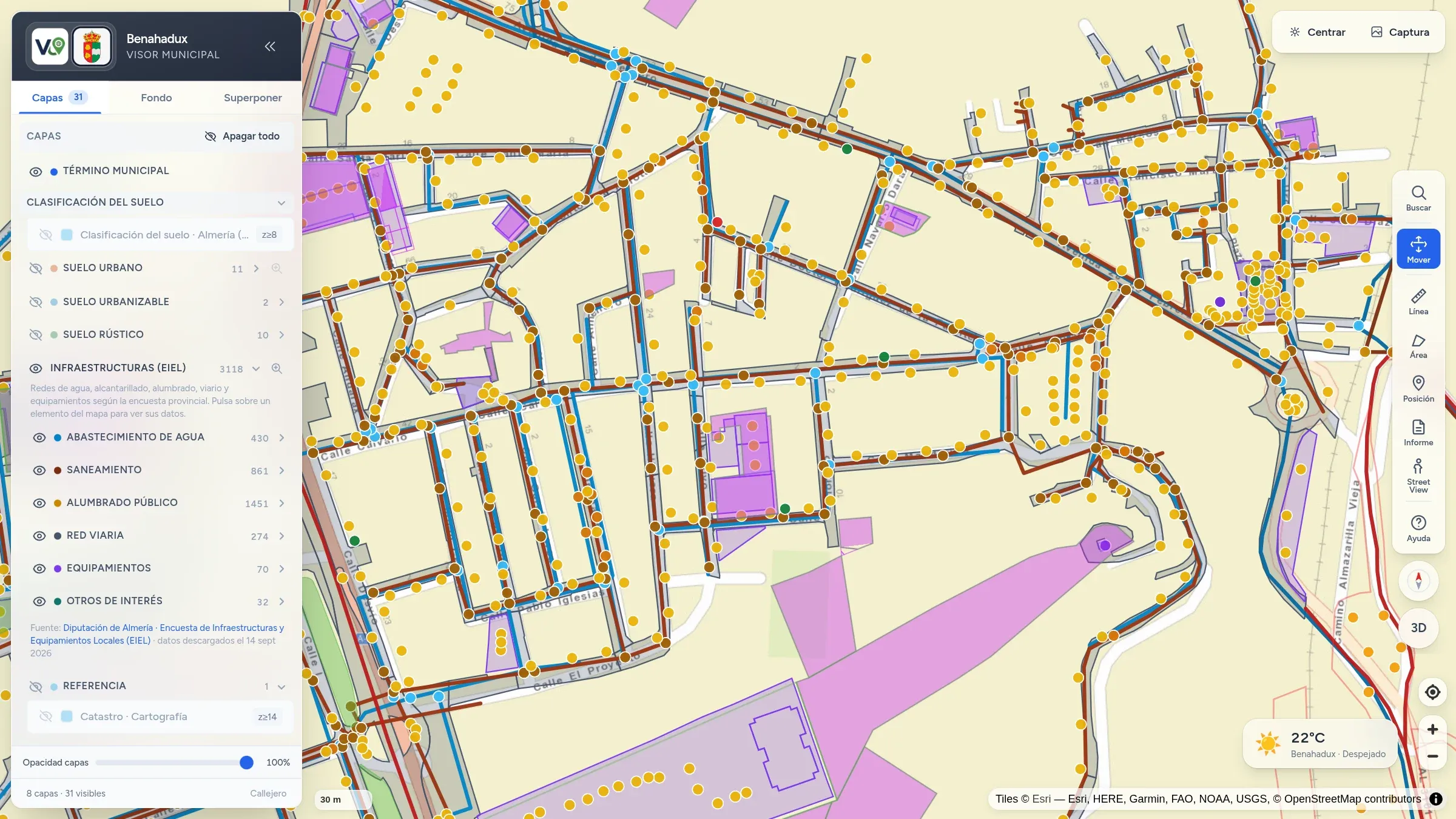
Water supply, sewerage, street lighting, streets and public facilities, with data from the Survey of Local Infrastructure and Facilities (EIEL) of the Provincial Council of Almería. Click on an element to see its material, condition or power.

  • Water supply, sanitation and street lighting
  • Road network and public facilities
  • Data for each element, with the codes already translated
  • Updates itself every month with the Provincial Council's data
Old town of Benahadux with the EIEL infrastructure: water and sanitation networks, light points and facilities.
Real screenshot

Measure and explore the terrain

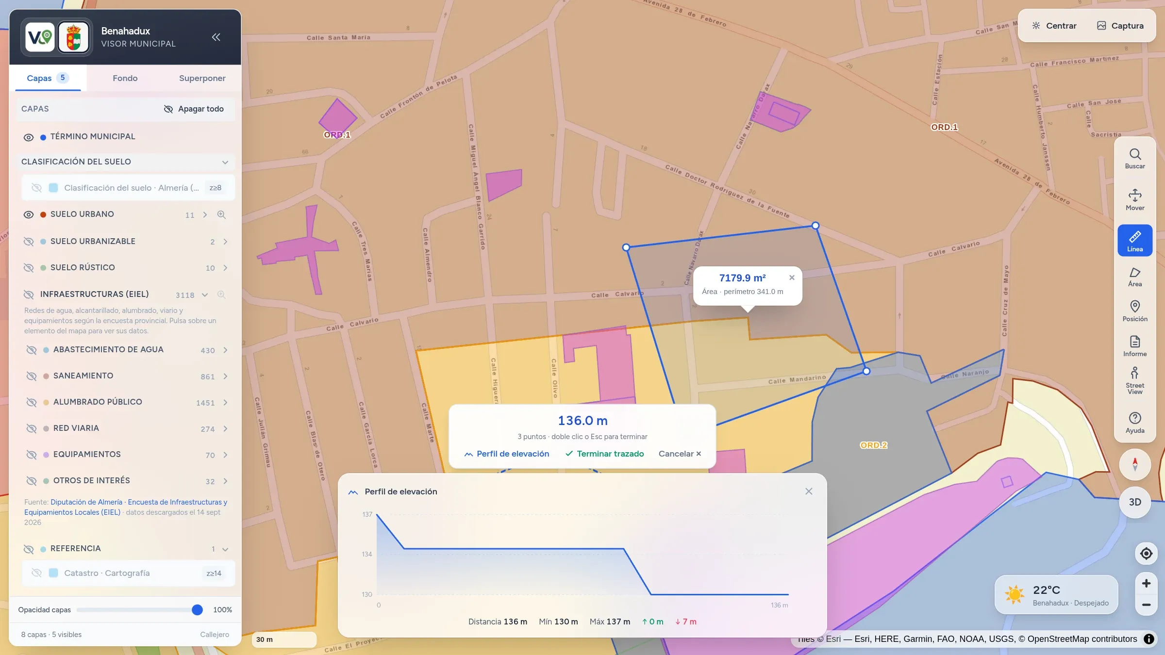
Measure distances and areas, get the elevation profile of a route and switch between ten base maps, including the Town Council's own orthophoto.

  • Distances and areas, several at once
  • Elevation profile of any line
  • 10 base maps: street maps, orthophotos, satellite and terrain
  • Street View and UTM ETRS89 coordinates
Measurement of an area of 7,179.9 m² and a line of 136 m, with its elevation profile.
Real screenshot

Integrated with Municipal Inventory

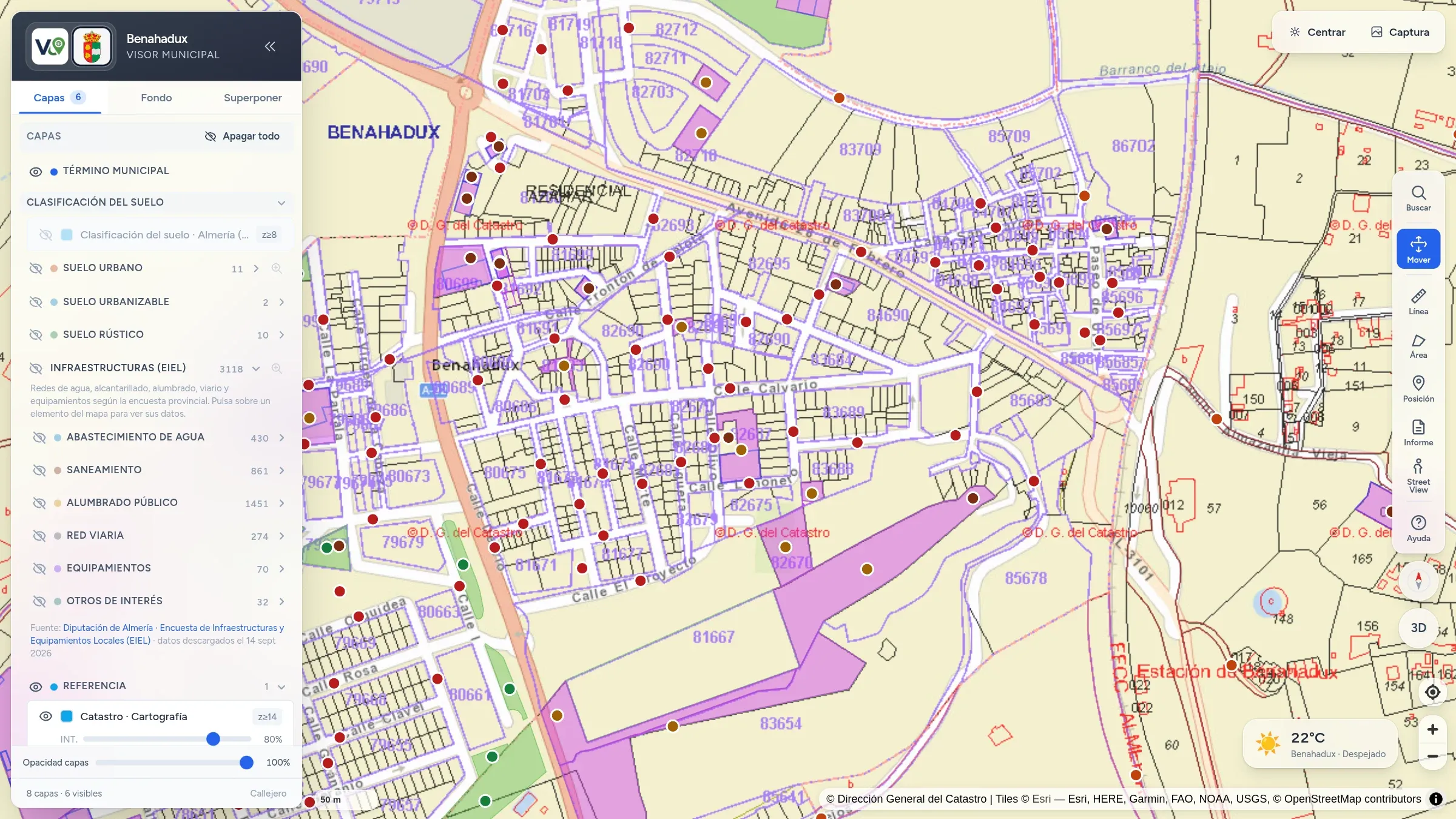
If the Town Council works with Municipal Inventory, its assets appear on the map and each municipal plot links to its record in the inventory.

  • Inventory assets on the map, by category
  • Notice «listed in the municipal inventory» when you query
  • Direct link to the asset's record
  • Inventory and urban planning on the same map
Assets of the Benahadux municipal inventory on the cadastral map.
Real screenshot

And much more…

Details that make the viewer more useful every day.

  • Street View

    Click on a street and see the Google view at that point.

  • Coordinates

    Geographic and UTM ETRS89 coordinates of any point, with a button to copy them.

  • Map capture

    Download what you see on screen as a PNG, with your measurements.

  • 3D view

    Terrain and buildings in three dimensions, with a compass to find your bearings.

  • Installable app

    Works on mobile phones and installs like an app, with the municipality's coat of arms.

  • Mobility layers

    Bike lanes, public transport and railways on the map.

  • Local weather

    Temperature and sky conditions, always in view.

  • The Town Council's own maps

    Its own layers are added from DXF files.

  • Always available

    If an agency's map server fails, the viewer keeps showing its cached copy.

Official data

Information from public sources, always available

The viewer brings together on a single map the Town Council's urban plan and the official services of the Spanish Cadastre, the Junta de Andalucía (Andalusian regional government), the Provincial Council and the State, always citing the source.

It also keeps a copy of what it queries: if an agency's server stops responding, the viewer keeps working.

  • Town Council Current urban plan, zoning ordinances, area sheets, DXF maps and municipal orthophoto
  • Directorate General for the Cadastre Cadastral mapping and plots
  • Junta de Andalucía REDIAM (flood zones, protected areas, livestock trails), CDAU street map and SIU
  • Provincial Council of Almería Survey of Local Infrastructure and Facilities (EIEL) and SIU
  • National Geographic Institute PNOA orthophoto and base mapping

How to get started?

Your viewer, published in four steps

  1. 1

    Request a demo

    We show you the viewer working with real data and answer your questions.

  2. 2

    You send us the urban plan

    Land classification and zoning ordinance maps, area sheets and any GIS or DXF layers the Town Council has.

  3. 3

    We add it and review it

    We digitize the urban plan and check it with the municipal technician before publishing it.

  4. 4

    Published for everyone

    The viewer goes live on your subdomain (municipality.visorurbanismo.es), ready to be linked from the municipal website.

Frequently asked questions

What people usually ask us

Is the report legally binding?

No. The information is for information purposes only and is not legally binding: it is not a certificate or official zoning certificate and does not prove any rights or obligations. Both the viewer itself and every report say so. For procedures with legal effect, you must contact the Town Council.

What does the Town Council need to provide?

Its current urban plan: land classification and zoning ordinance maps, area sheets and, if available, GIS layers or DXF files. The other sources (Spanish Cadastre, Junta de Andalucía, Provincial Council, IGN) are added by the viewer.

Where does the data come from?

The urban planning information comes from the current municipal urban plan and the Town Council's layers; the mapping and plots, from the Directorate General for the Cadastre; and the other layers, from public services of the Junta de Andalucía, the Provincial Council of Almería and the State.

How often is it updated?

The Spanish Cadastre and the layers of public agencies are queried from their official services. The EIEL infrastructure data updates itself every month. The municipal urban plan is updated when the Town Council approves changes and sends them to us.

Who can use it?

Anyone, without registering: the viewer is public. Only layer management requires administrator access.

Do I need to install anything?

No. It is a cloud service that runs in the browser on a computer, tablet or mobile phone, and it can be installed as an app.

Want to see the viewer in action?

Request a personalized demo with no obligation.

Request demo

Request your free demo of Visor Urbanismo

Tell us what your Town Council needs and we will show you the viewer working with real data.

Free initial advice

Personalized demo at no cost and with no obligation.

Write to us

Controller: Inventarios de Bienes y Derechos, S.L.. Purpose: to handle your request and, if you tick the box, to send you news. Rights: access, rectification, erasure and others, by writing to info@inventariomunicipal.es. More information in the privacy policy.